Tuindorp Vreewijk
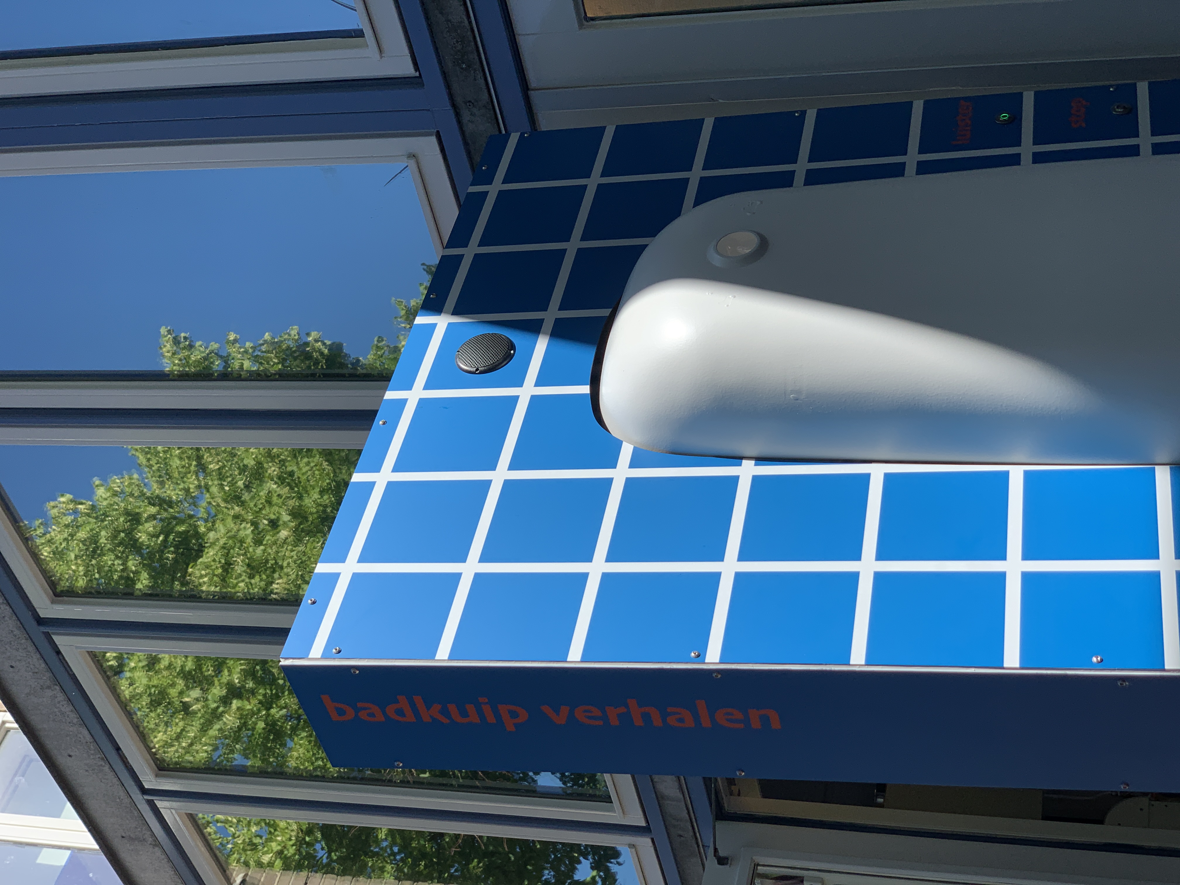
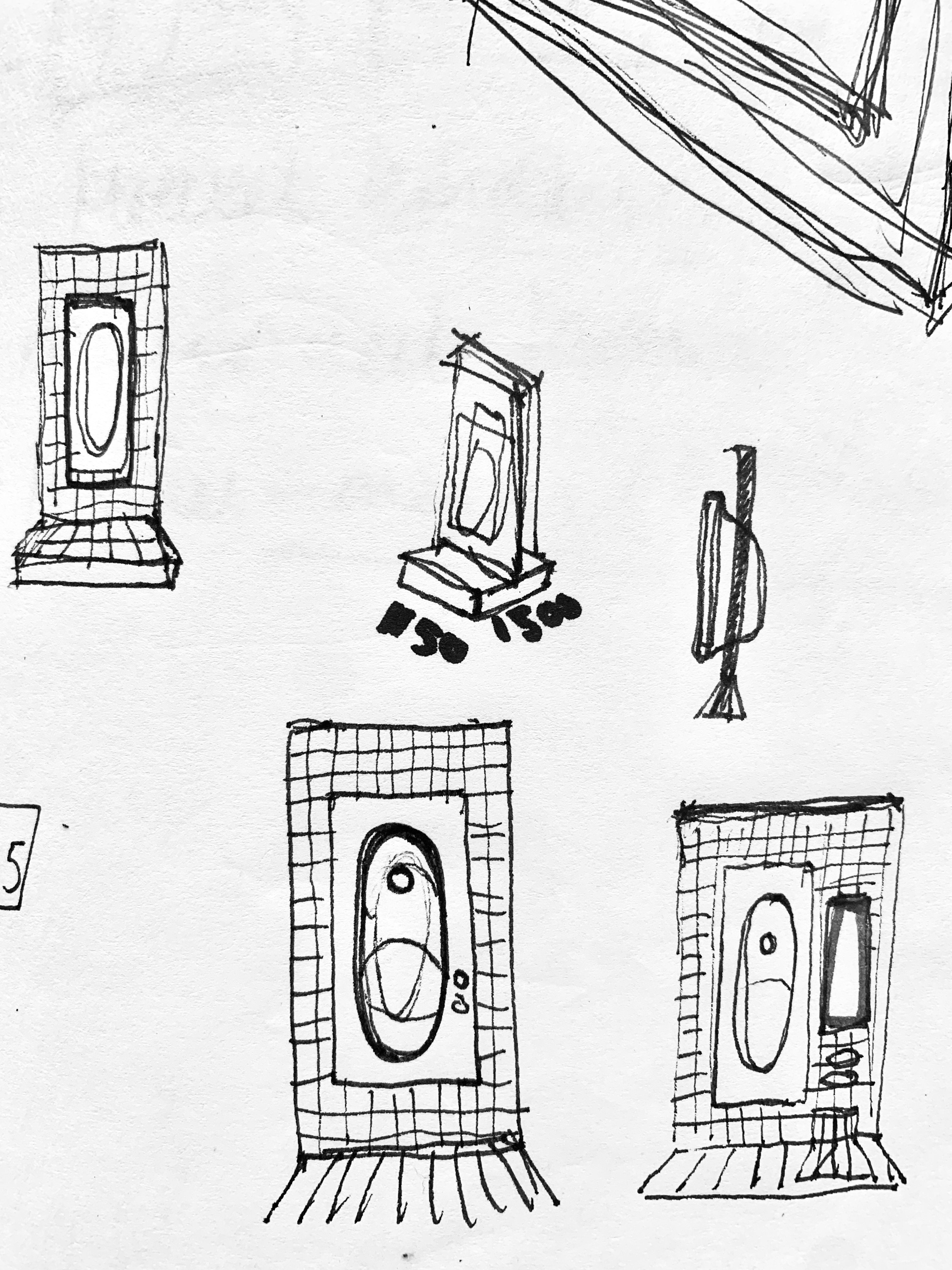
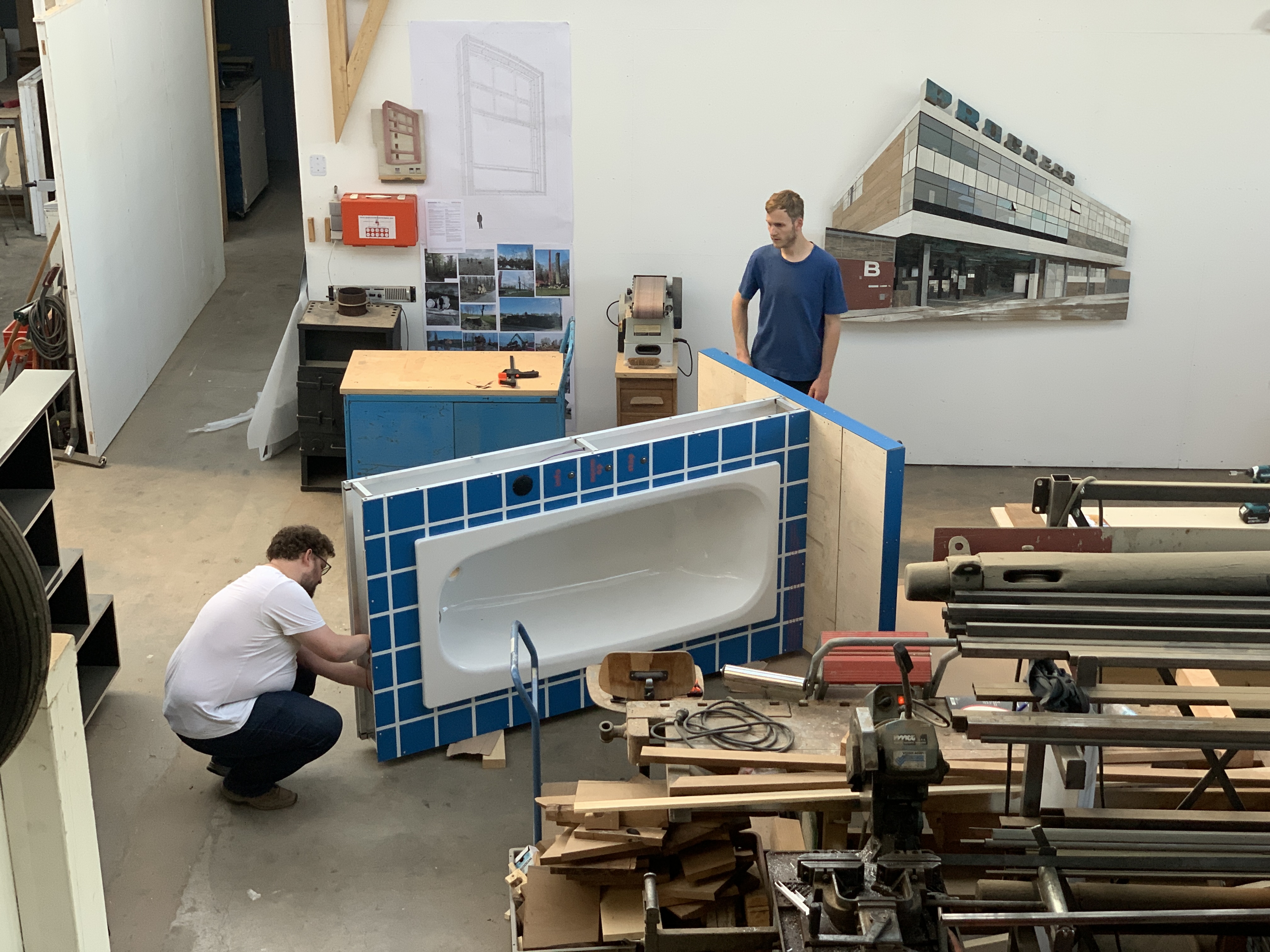
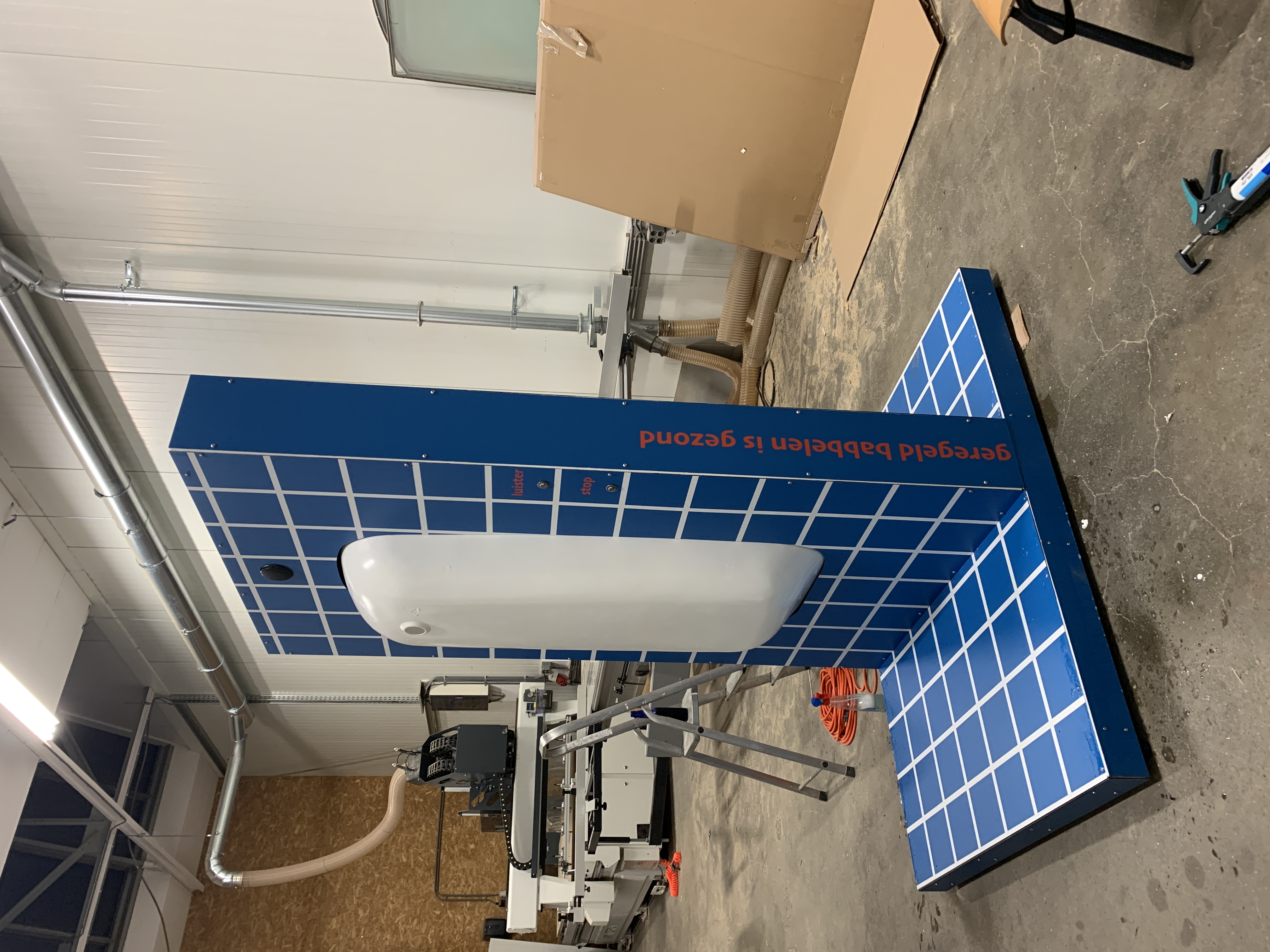
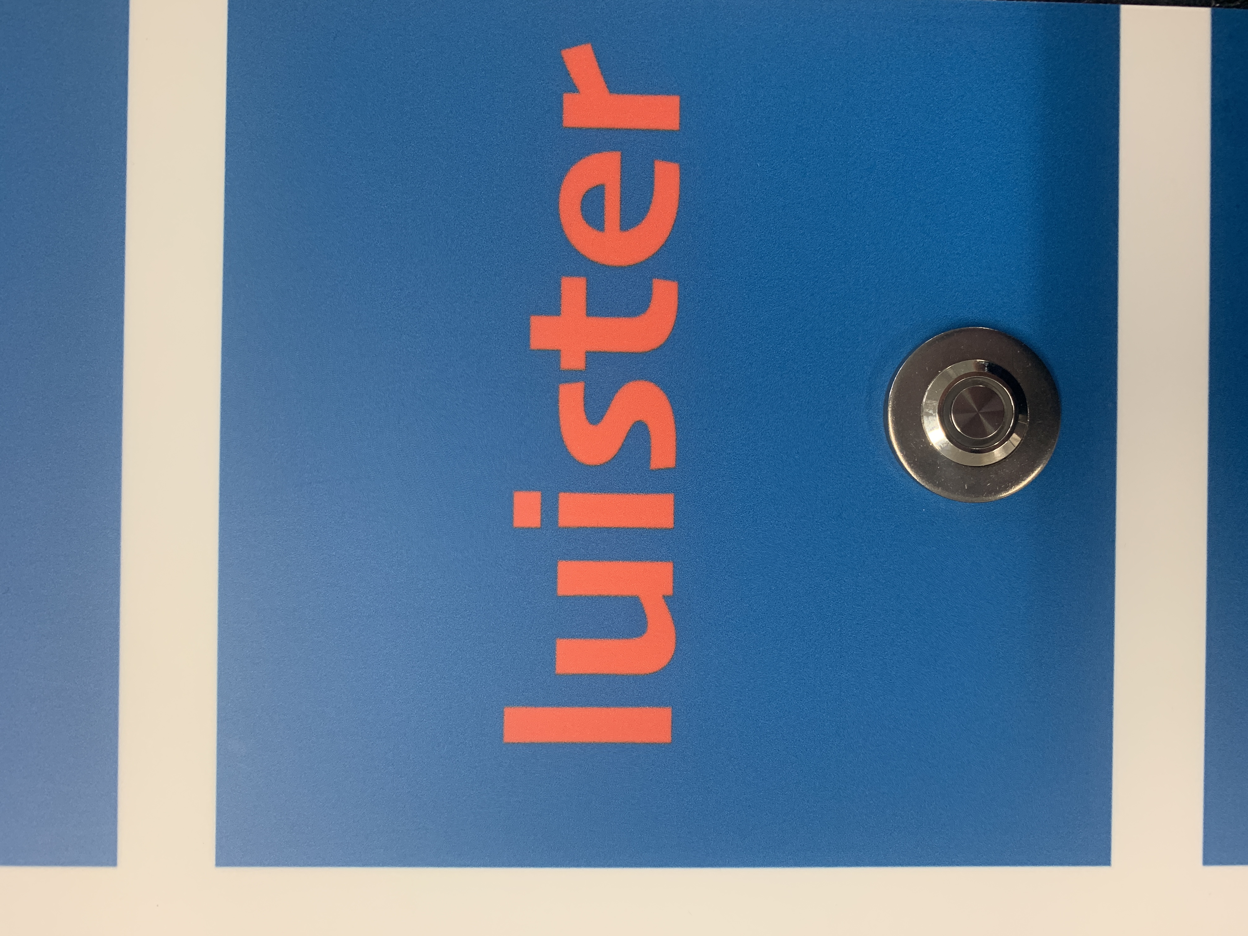
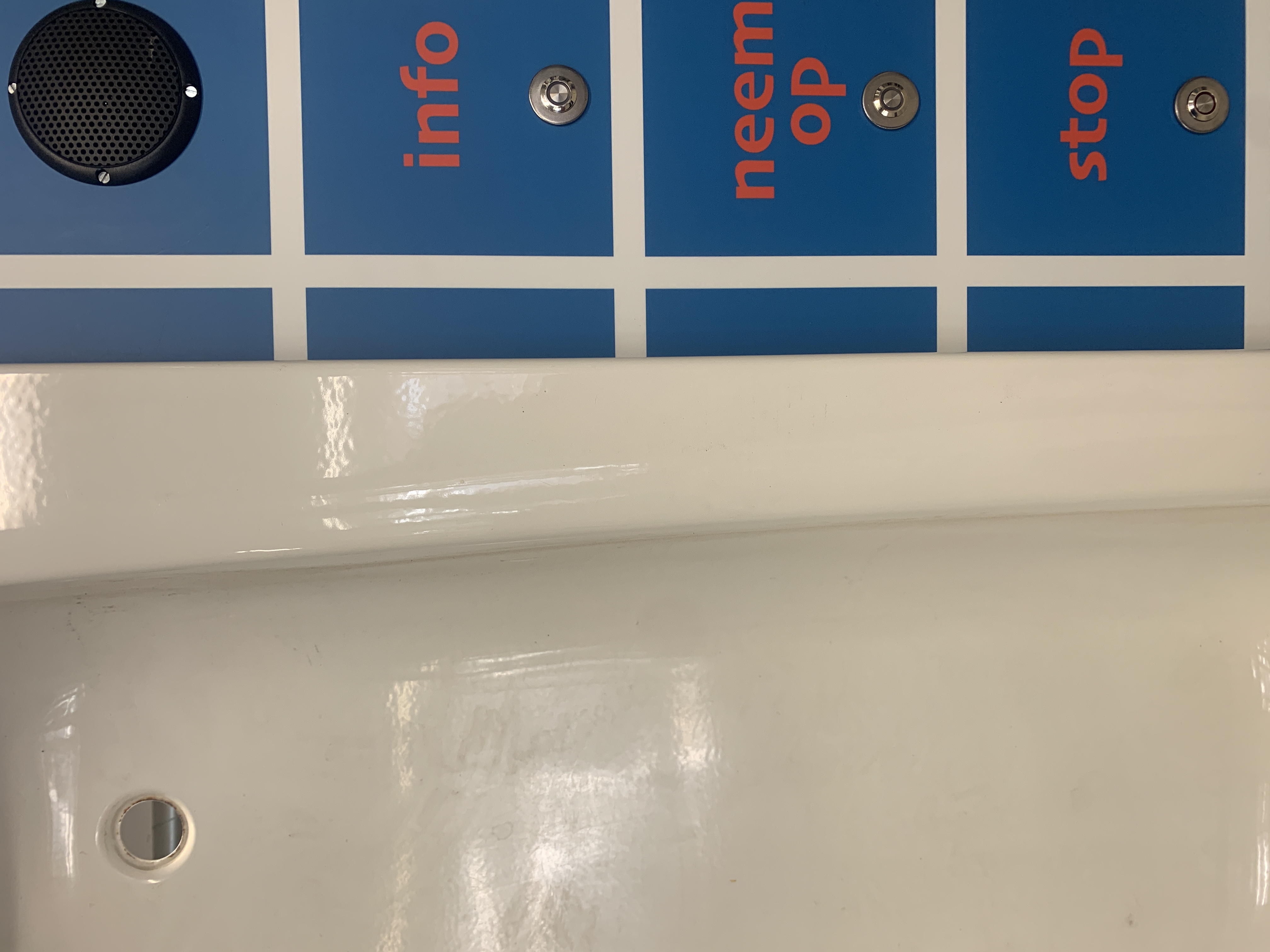
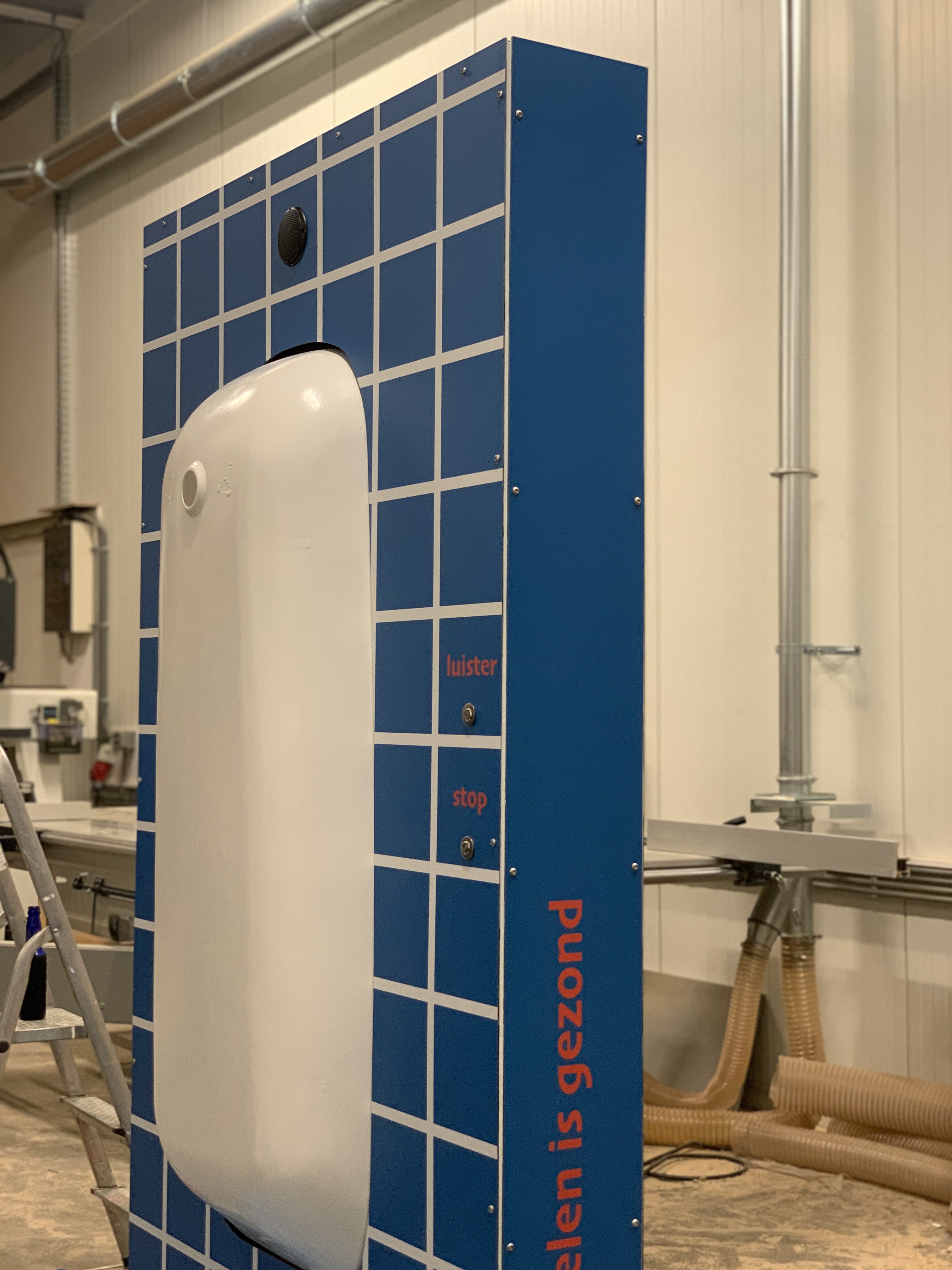
BADKUIP
VERHALEN
VERHALEN


2022 - Vreewijk - Rotterdam
This installation was made possible in part by
Experiment Grant Scheme of Stimuleringsfonds and Gemeente Rotterdam in collaboration with Attach Studio and Digital Mass, Interactive Media
Part of the project Performing the City
Cultuuronderzoekers: Artistic Researcher
Chih-Hsun Chien and Landscape artist Janneke Derksen
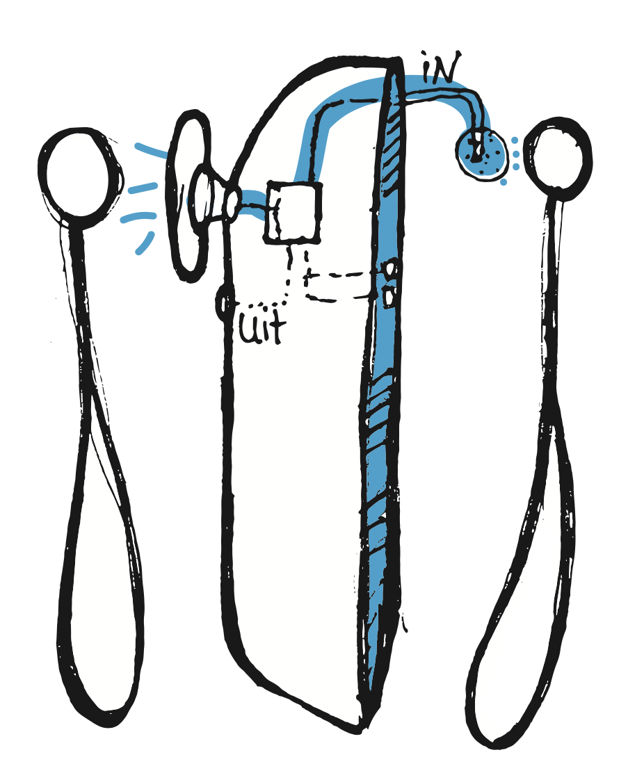
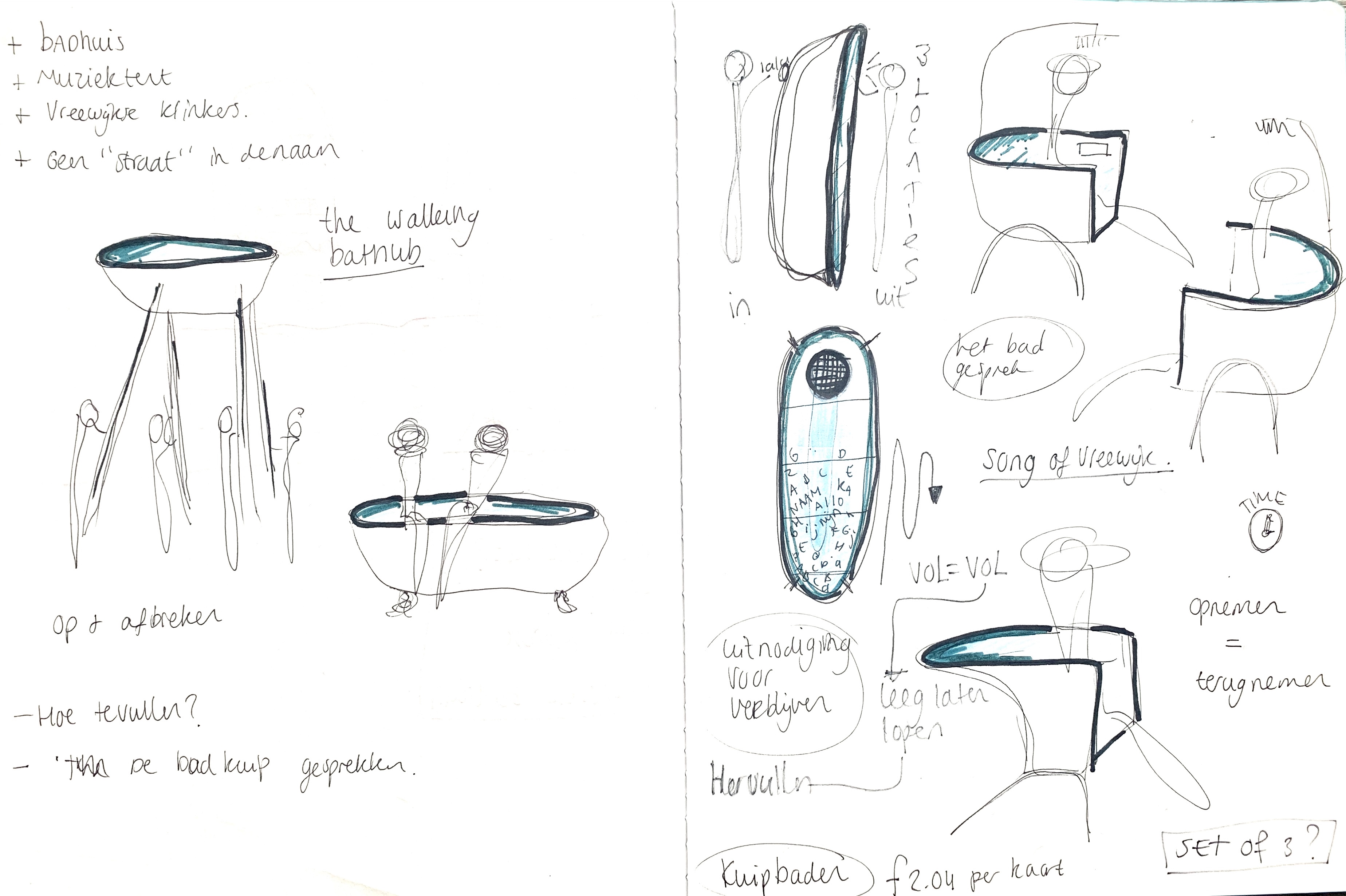
The installation was inspired by the cigar shop’s old community telephone, as well as the neighbourhood’s public bathhouse. Before the bathroom became a ‘domestic’ part of the household, people used to go to the collective bathhouse. A place where spontaneous meetings took place between neighbours in the past. The bathtub offers the idea to give residents the chance to “pour in” what they want to say and to “be engulfed” by the words of others, all anonymously and spontaneously. The installation has two sides, each with its own function. At the front is the possibility to record your personal story of what you want to “pour” in the bathtub. Some speak, others sing! At the back you can listen to the recorded stories from the front.
This installation was made possible in part by
Experiment Grant Scheme of Stimuleringsfonds and Gemeente Rotterdam in collaboration with Attach Studio and Digital Mass, Interactive Media
Part of the project Performing the City
Cultuuronderzoekers: Artistic Researcher
Chih-Hsun Chien and Landscape artist Janneke Derksen
The installation was inspired by the cigar shop’s old community telephone, as well as the neighbourhood’s public bathhouse. Before the bathroom became a ‘domestic’ part of the household, people used to go to the collective bathhouse. A place where spontaneous meetings took place between neighbours in the past. The bathtub offers the idea to give residents the chance to “pour in” what they want to say and to “be engulfed” by the words of others, all anonymously and spontaneously. The installation has two sides, each with its own function. At the front is the possibility to record your personal story of what you want to “pour” in the bathtub. Some speak, others sing! At the back you can listen to the recorded stories from the front.
The experiment behind the installation
Within the experiment also the location of the installation became part of the experiment. Has the direct context of the installation in the (public)space influenced how the residents experience the installation? Therefore the installation has been placed in various places in Vreewijk since May, 2022.
( around 3 weeks on each location)
Leeszaal Vreewijk, along the main road in the neighbourhood
The concept is simple: you take books that you no longer read to the reading room and you can exchange them by picking out other books. You can then exchange, return, keep or pass on these books. We are not a library. We hope this will promote reading and reading pleasure. We have a library of books for all ages.
Stichting de Uil, in one off the collective
garden surrounded by houses
We help residents of Vreewijk with a low
income with jobs in and around the house.
Wijkhuis De Brink, in the core of the neighbourhood
next to the Brink square
Wijkhuis de Brink is a multifunctional building, where young and old can go for all kinds of activities.
It is the meeting place for the neighbourhood.
De Educatieve Tuin, along the outskirts of the neighborhood
Every season, children from primary school, secondary education, after-school care and daycare can be gardened. Gardens are also available to rent for residents of De Enk.
A beautiful and cozy location,
where you can garden from about April to the end of January.


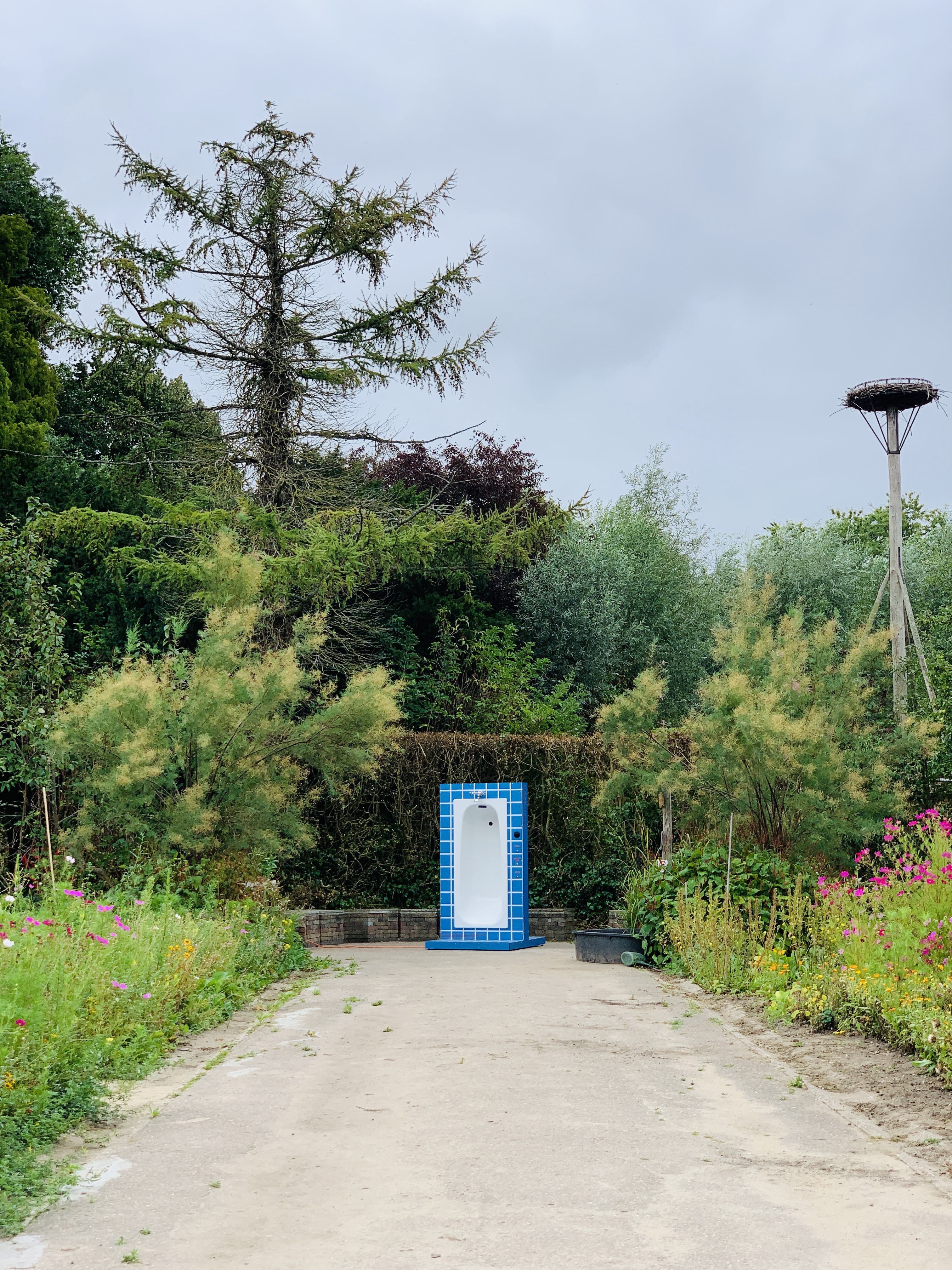

The experiment of the installation has shown ways of support and connections between the residents and organizations on various fronts. At first the bathtub is a recognizable object
for everyone that was placed in a new context. It became a common curiosity based on the recognizable shape of the bathtub. It opened up conversations and connections without being linked to everyday problems or political topics in the neighborhood.
for everyone that was placed in a new context. It became a common curiosity based on the recognizable shape of the bathtub. It opened up conversations and connections without being linked to everyday problems or political topics in the neighborhood.
‘Kan ik een koud bad nemen?’‘
‘’Mag ik in bad?’‘
’’Is dat een badkuip?’‘
‘’Komt er water uit?’‘
‘’Waarom een badkuip?’‘
‘’Moet de badkuip niet liggen?’‘
‘’Weet jij wat je met die badkuip moet doen?’‘
‘’Heb je de badkuip al zien staan?’‘
‘’Wanneer gaat de badkuip weer weg?’’
Second, the installation made new connections between the different organizations(locations). Some of the chosen locations are not directly prohibited with each other (target groups). Because the bathtub traveled around,over time it became a recognizable object linked to its location. Out of curiosity, residents were asking what will be the next location, it happened that people did not know the next location. Through the bathtub they came into contact with the organization and activities they organized.
‘’Verkoop je sanitair?’’
(resident walked into the Wijkhuis),
‘‘De Educatieve tuin? Is dat in Vreewijk?’‘
‘’He dat is de badkuip die bij de Leeszaal stond, mag die ook bij ons komen te staan?’ (Wijkhuis De Brink)
Overall the installation was often used by kids in the neighbourhood, and they followed the installation over the different locations. They talked, yelled, and sang! Some of the organizations spoke about the activities they offer, and to invite residents. One resident wrote their story out on paper, and visited the Badthub to record the story.
In the end we can say that bathtub became part of the society for some period of time. It worked to activate a place for young and old, and it connected residents in various ways. Each with their own experience with a common object: The Bathtub


Taipei, Taiwan
“WHO BUILD
THE CITY?’’
THE CITY?’’


2021 - Tapei - Taiwan
Supervisor| Ministry of Culture
Presenter| Taiwan Contemporary Culture Lab
(C-LAB)
Invited Contributor, Artist Residency
“Who builds the city?“
We are not only civilians of an urban landscape, but also can be seen as modelers of our cities. Within the exhibition, we will invite participants to come together to brainstorm and build a miniature city model according to their imaginations towards future possibilities of the city. Through the game-oriented format of role-playing, we set out to explore the challenges that may be faced within the city, and use different "tasks" within the game as a guide for discussion to simulate the evolution of the first-level city and rethink about our relationship with the city. In the project, artists from Taiwan, the Netherlands, Germany and South Korea will be invited to hold workshops to experiment with different possibilities in the city through multiple urban experiences and intervention methods.
Curators: Yu-Chin Ku, I-Chieh Liu, Huai-Chih Liang
Artists: Group B,Janneke Derksen, Sarah Bovelett, Minsun Kim, millonaliu(Klodiana Millona & Yuan-Chun Liu)


The hidden Tamsui patterns;
learning from the river
Research and development initiated
by jannekederksen in support
and collab with “Who builds the city?’’
Click here for more information
![]()
learning from the river
Research and development initiated
by jannekederksen in support
and collab with “Who builds the city?’’
Click here for more information

Workshop
learning from the dike
Research and development initiated
by jannekederksen in support
and collab with “Who builds the city?’’
Click here for more information
learning from the dike
Research and development initiated
by jannekederksen in support
and collab with “Who builds the city?’’
Click here for more information
.
Outcome - interactive dike
Research and development initiated
by jannekederksen in support
and collab with “Who builds the city?’’
Find the outcome of the installation and workshop in the final part of page: workshop learning from the dike Click here![]()
Research and development initiated
by jannekederksen in support
and collab with “Who builds the city?’’
Find the outcome of the installation and workshop in the final part of page: workshop learning from the dike Click here

Taipei, Taiwan
THE HIDDEN PATTERNS OF THE TAMSUI RIVER


2021 - Tapei - Taiwan
Supervisor| Ministry of Culture
Presenter| Taiwan Contemporary Culture Lab
(C-LAB)
Invited Contributor, Artist Residency
Research and development initiated
by jannekederksen in support
and collab with “Who builds the city?’’
The hidden Tamsui patterns;
learning from the dike
The Taipei Basin was characterized geographically in two district river cultures; Tamshui River as commercial transport for tea, rice and camphor and the agricultural Keelung River. Where the focus of globalization-driven urbanization and the threats of floods had the lead in how we experience the relation between the river and the city, from the past to today. In 1971, channels and dikes were once identified
as the most feasible solution of protecting the Taipei Basin, where the engineering methods had won it from the natural river processes.
When most existing studies are about
the technical river in relation to the urban development of the city, this research will zoom in on the social and physical obstacles resulting from all those developments: the dike!
1) Looking forward
“Learning from the dike” studies how the dikes developed in Taipei, and how they function now, in order to speculate and formulate the future redevelopment design, questioning this safety network which should contain the discharge of 200-year floods.
“Learning from the dike” studies how the dikes developed in Taipei, and how they function now, in order to speculate and formulate the future redevelopment design, questioning this safety network which should contain the discharge of 200-year floods.
2) Time
The river used to be a friend full of resources and prosperities where settlers tended to live as close as possible to the water source. Over the years, influenced by (il)legal industrial activities and extreme weather conditions(e.g. typhoons), the river turned into an unexpected enemy where protection is necessary in order to protect the urban area. In 1971, the Flood Control Plan was drawn up, a plan where floodwalls, levees and pump stations were the sole solution to shield the urban hub. As the plan was completed, the river became sealed off from residents’ daily life.
The river used to be a friend full of resources and prosperities where settlers tended to live as close as possible to the water source. Over the years, influenced by (il)legal industrial activities and extreme weather conditions(e.g. typhoons), the river turned into an unexpected enemy where protection is necessary in order to protect the urban area. In 1971, the Flood Control Plan was drawn up, a plan where floodwalls, levees and pump stations were the sole solution to shield the urban hub. As the plan was completed, the river became sealed off from residents’ daily life.
3) Flood control plan
The Flood Control plan did not include ecological or social based flood control strategies for the preserves of wetlands and floodplains, for this would have impeded on land reclamation projects by the riverside. On top of the lacking aspects for the preserves, due to the limited space between the city and the river, the result therefore was the dike with protection walls of 9.68m height along most of the length of the river.
The Flood Control plan did not include ecological or social based flood control strategies for the preserves of wetlands and floodplains, for this would have impeded on land reclamation projects by the riverside. On top of the lacking aspects for the preserves, due to the limited space between the city and the river, the result therefore was the dike with protection walls of 9.68m height along most of the length of the river.
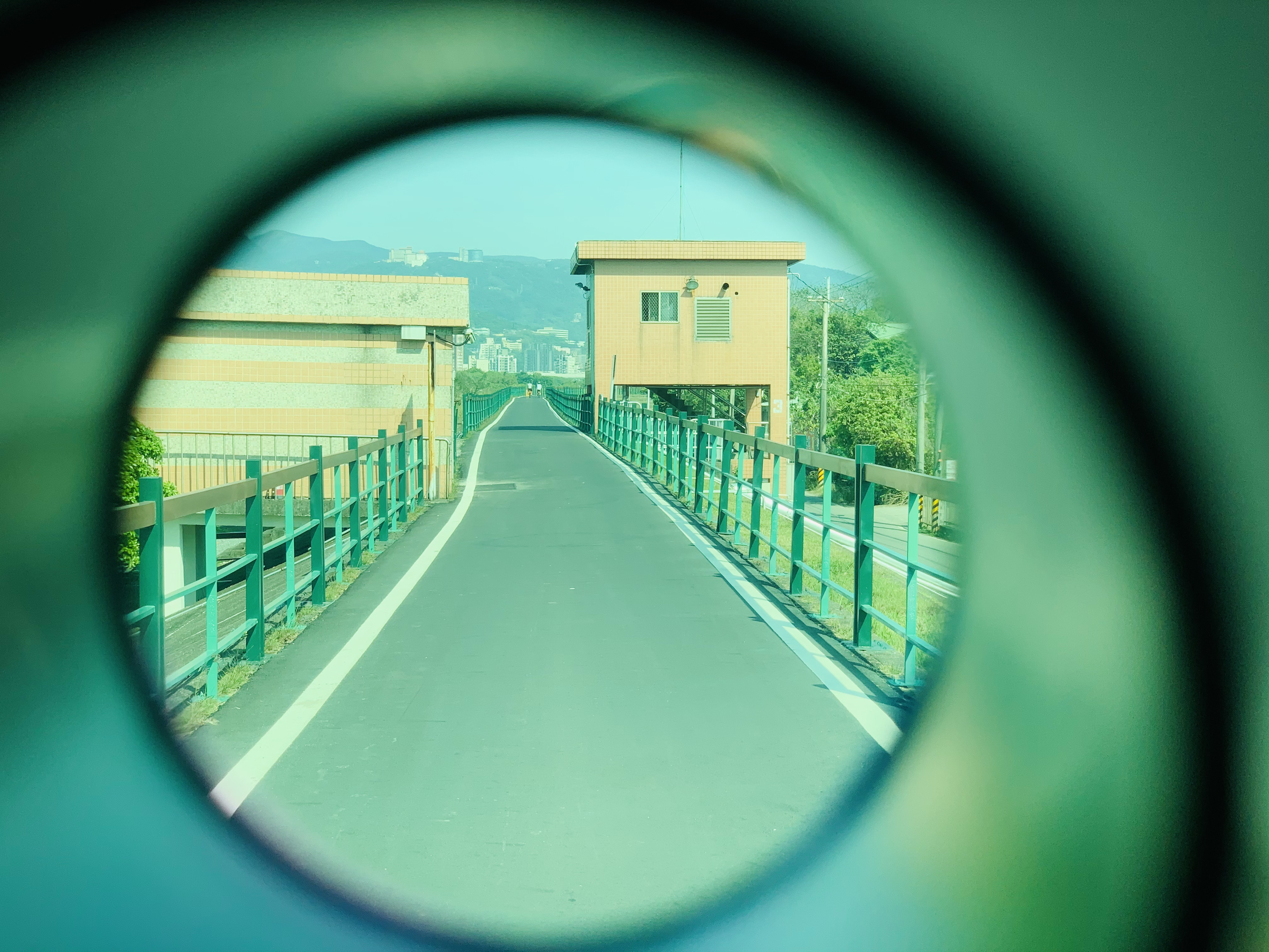
4) Unnamed public space
A new public place was formed hidden from the city and its inhabitants. These places
are democratic and inclusive, personal and anonymous at the same time; Time does not seem to exist and the city shielded by the wall does not exist, either. They are spaces without inhabitants – since the regulation forbids this.
5) Reading the dike
What does the dike look like in relation to the river and her city? What is there to be found? How have they been used in the past and how are they used today; what is the social and spatial impact over the years; are there layers of use that have been erased and if so, which? And what is the social meaning of the dike nowadays?
What does the dike look like in relation to the river and her city? What is there to be found? How have they been used in the past and how are they used today; what is the social and spatial impact over the years; are there layers of use that have been erased and if so, which? And what is the social meaning of the dike nowadays?
6)Methodology
1. Local sources: Literature research and interviews from experts and inhabitants
2. Perspective from an outsider: Field research, on-site observations, and analysis of these observations and documentation
3. Narrative mapping with audio: information translating into a drawing, which includes the hidden patterns of the river and the dike of Taipei, providing participants with guidance of how to read and to experience
4. Back into the field: emergence of outsiders’ perspective with local experience
5. Documentation
Learning from the river
The Hidden Patterns of the Tamsui River is a collection of research from an outsider perspective, translated into an open and accessible format.
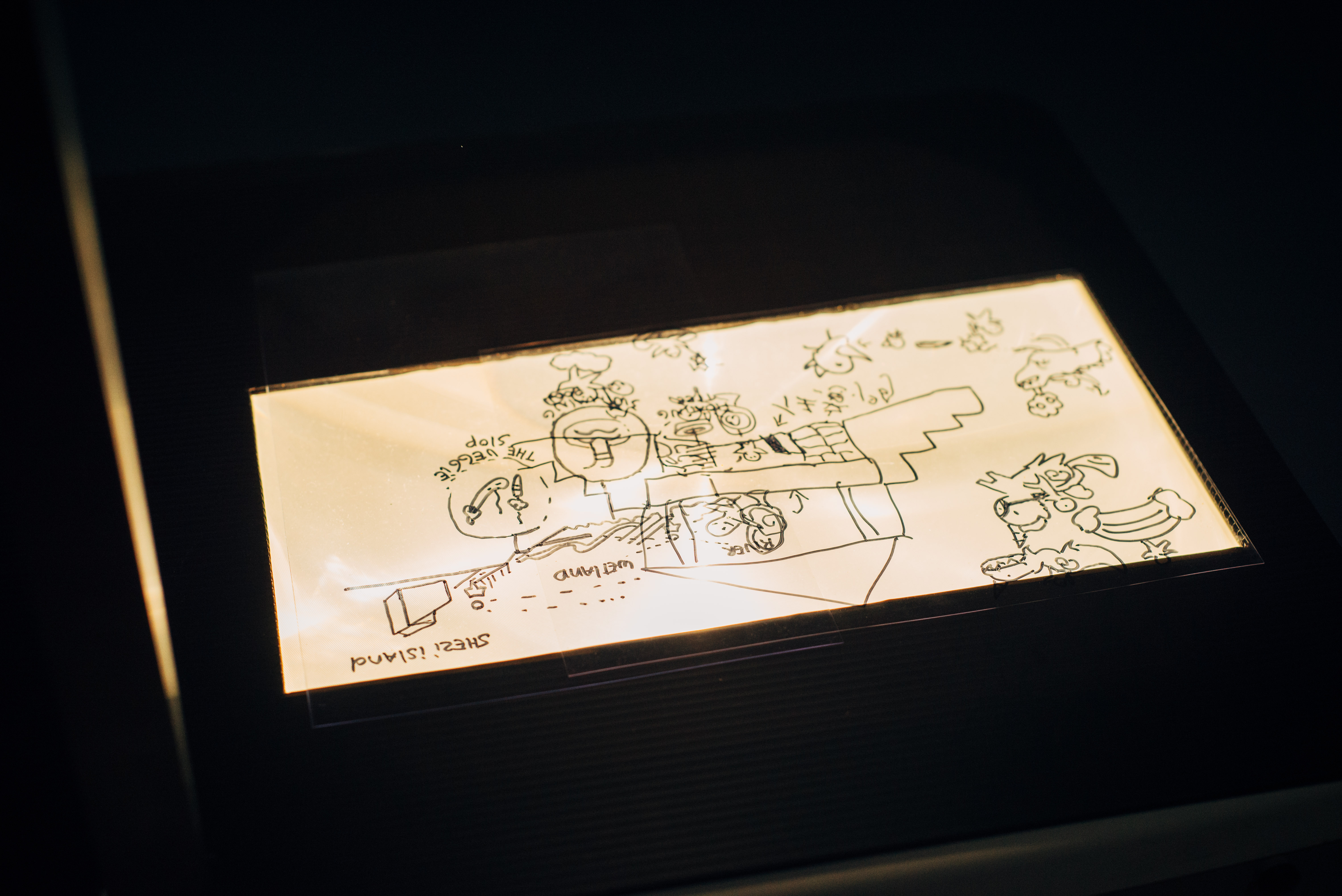
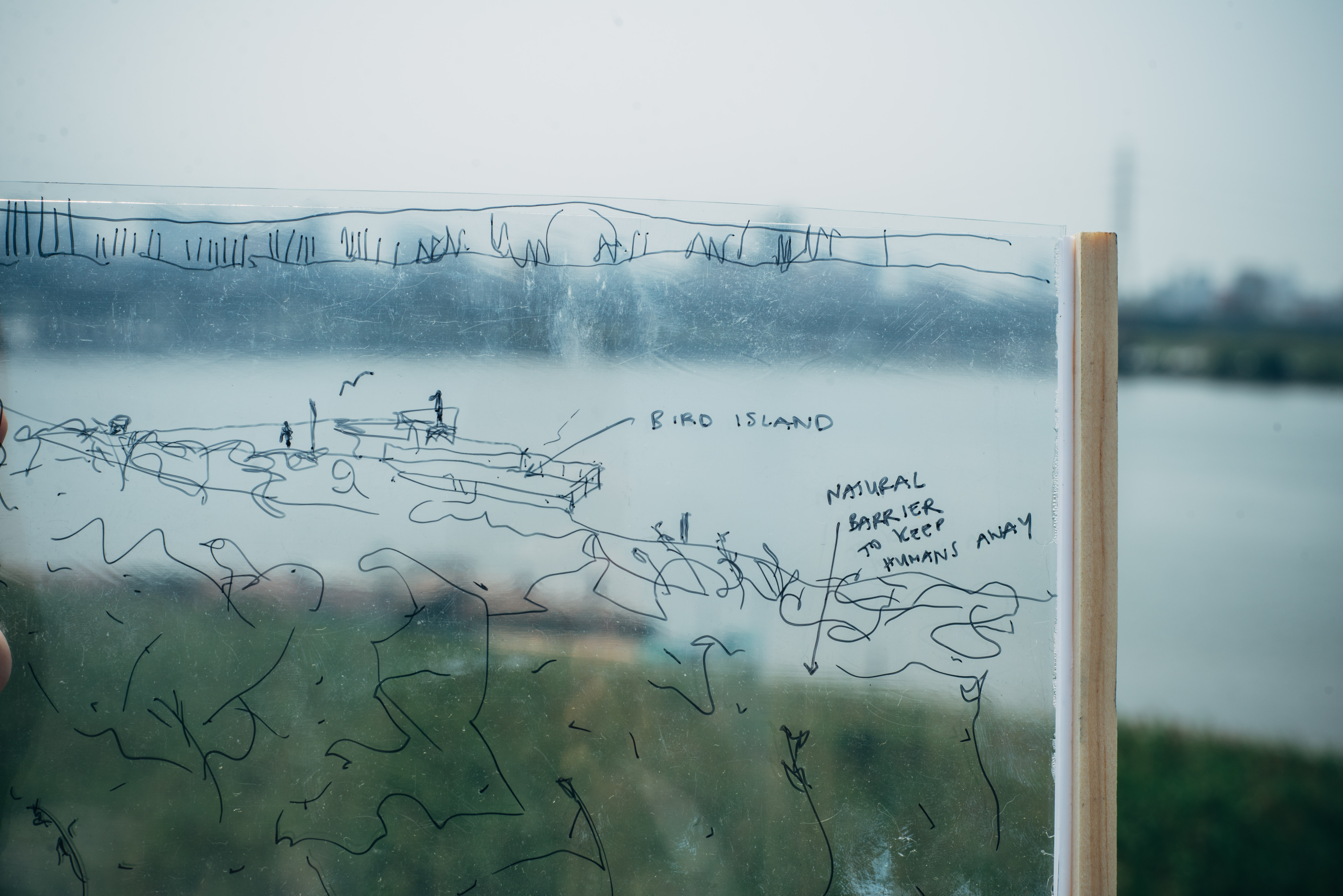
The four audio stories explain how the dike system came into existence, which layers are erased, and the possibility to reverse the approach, and the introduction of Shezi- Island, a place which offers opportunities.
The participants are invited to guide themselves to read and to experience the hidden patterns of the river and the dike of Taipei on the journey. Then they will be asked to sketch their own proposal for the dike on Shezi Island. We use the dike as
a starting point to improve the horizontal relationship between the river and the city.
The Hidden Patterns of the Tamsui River is a collection of research from an outsider perspective, translated into an open and accessible format.
The four audio stories explain how the dike system came into existence, which layers are erased, and the possibility to reverse the approach, and the introduction of Shezi- Island, a place which offers opportunities.
The participants are invited to guide themselves to read and to experience the hidden patterns of the river and the dike of Taipei on the journey. Then they will be asked to sketch their own proposal for the dike on Shezi Island. We use the dike as
a starting point to improve the horizontal relationship between the river and the city.

1) Why is it there?
The Taipei Basin was characterized geographically in two district river cultures; Tamshui River as commercial transport for tea, rice and camphor and the agricultural Keelung River. Where the focus of globalization-driven urbanization and the threats of floods had the lead in how we experience the relation between the river and the city, from the past until today. In 1971, canals and dikes were identified as the most feasible solution of protecting the Taipei Basin as the engineering methods intercepted the natural river flow. Since most studies are about the technical aspects from the river, in relation to the urban development of the city, this research will zoom in on the social and physical obstacles resulting from all the developments: the dike.
The Taipei Basin was characterized geographically in two district river cultures; Tamshui River as commercial transport for tea, rice and camphor and the agricultural Keelung River. Where the focus of globalization-driven urbanization and the threats of floods had the lead in how we experience the relation between the river and the city, from the past until today. In 1971, canals and dikes were identified as the most feasible solution of protecting the Taipei Basin as the engineering methods intercepted the natural river flow. Since most studies are about the technical aspects from the river, in relation to the urban development of the city, this research will zoom in on the social and physical obstacles resulting from all the developments: the dike.
2) The other way around
The Flood Control plan did not include ecological or social based flood control strategies for the preserves of wetlands and floodplains, for this would have impeded on land reclamation projects by the riverside. On top of the lacking aspects for the preserves, due to the limited space between the city and the river, the result therefore was the dike with protection walls of 9.68m height along most of the length of the river. But what if we turn it the other way round? With the new urban development we take the dike as a starting point to create new additional models for the dike, improving the horizontal interactions from the river to her city, and vice versa. Where will the hidden patterns of the river be reconnected to and, perhaps, be visible again?
3)Which layers are erased?
The river is weak, suffering from the industrial traces. Eighty years ago, the water was still clean enough for drinking and cooking; fish and shrimps were there to be found. Fishermen and sampans were seen everyday plying the river. Since the 60s, the focus for economic activity and population growth in Taipei Metropolitan has increased. The ‘people beat nature‘ mentality to protect the urbanization of flood threats, resulted in a wall of 9.68m height amongst others. Once the river was so close to the locals, now it is increasingly separated. Landowners, factory investors, and land speculators moved into the watershed to replace rural communities. Agricultural land was reformulated to meet the requirements of manufacturing and urban development. Water resources for irrigation were destroyed and the rice culture of the river disappeared.
The river is weak, suffering from the industrial traces. Eighty years ago, the water was still clean enough for drinking and cooking; fish and shrimps were there to be found. Fishermen and sampans were seen everyday plying the river. Since the 60s, the focus for economic activity and population growth in Taipei Metropolitan has increased. The ‘people beat nature‘ mentality to protect the urbanization of flood threats, resulted in a wall of 9.68m height amongst others. Once the river was so close to the locals, now it is increasingly separated. Landowners, factory investors, and land speculators moved into the watershed to replace rural communities. Agricultural land was reformulated to meet the requirements of manufacturing and urban development. Water resources for irrigation were destroyed and the rice culture of the river disappeared.
4) Shezi - Island
Shezi-island is a political backyard of
Taipei, a sandbank that has been shaped by the natural process of the river and identified back in the time as a flood plain in the downstream section of the Keelung River. The settlement of big families since the Qing Dynasty in combination with the floodplain measures over the years, have had a strong impact on the agriculture identity of the Island.
With pressure from the various local communities and the government, the urban developments of the island have been on the political agenda for more than 30 years already. How do we make sure that we do not adopt the same approach as in the past? This case study of Shezi-Island
is expected to bring in the most feasible solution of protection and development of the area with the balance between nature and social aspects.

Taipei, Taiwan
WORKSHOP
LEARNING
FROM THE DIKE
LEARNING
FROM THE DIKE


2021 - Tapei - Taiwan
Supervisor| Ministry of Culture
Presenter| Taiwan Contemporary Culture Lab
(C-LAB)
Invited Contributor, Artist Residency
Research and development initiated
by jannekederksen in support
and collab with “Who builds the city?’’
Workshop
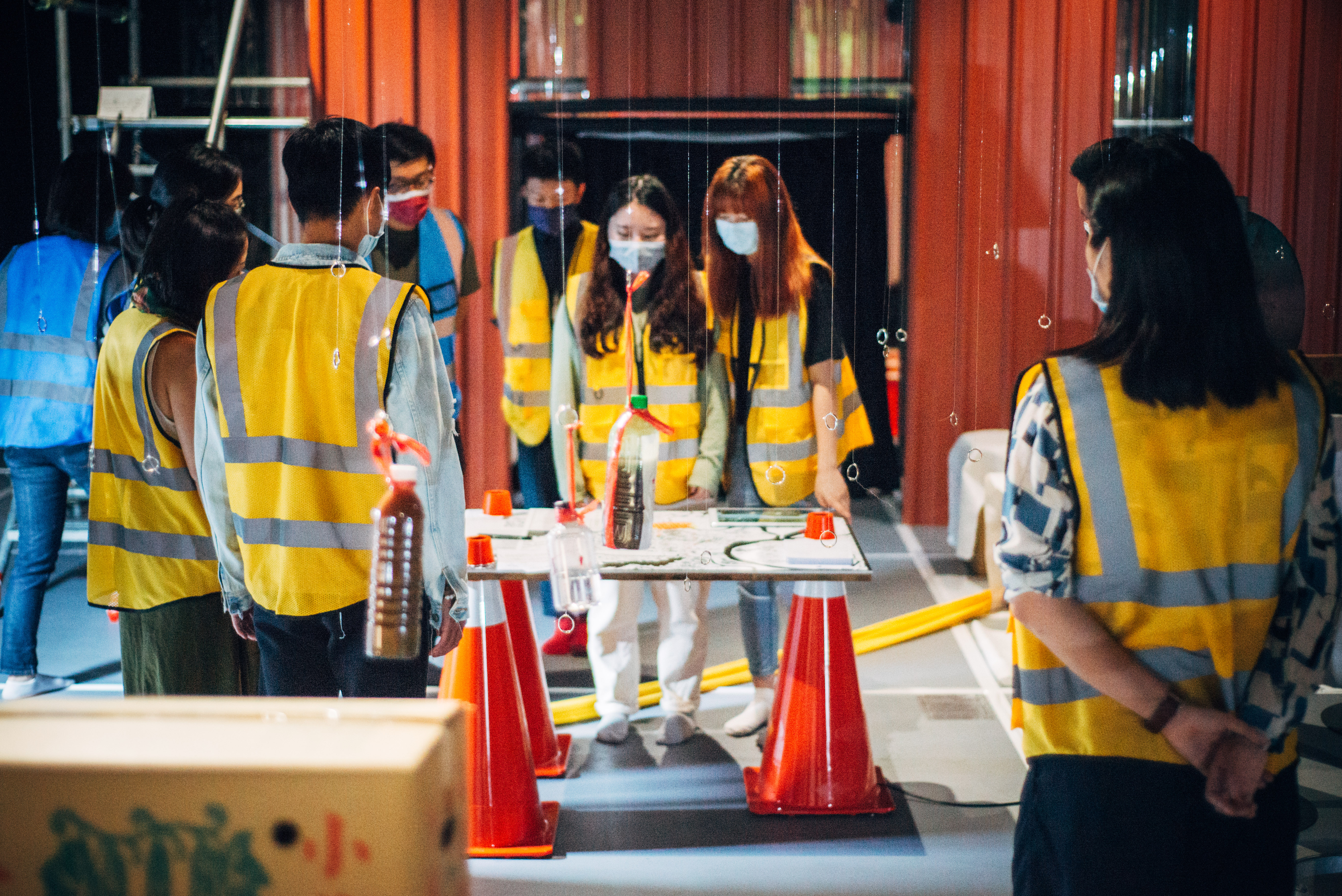
Learning from the dike
The workshops aim to discover the Hidden Tamsui patterns, where facts and figures are shared directly in the field to shed light on the participants’ experience on the topic and to develop a new perspective. With the starting points of questions at how the social and spatial relationship developed between the dike of the Tamsui River in Taipei, why is it there? How have they been used in the past and how are they used today? What are the ways they function and the visual language they have developed? Are there any erased layers of use? And if so, which? What does the dike look like in relation to the river and the urban hub? All the workshops are in order to speculate and formulate the design question of this safety network: the dike
Supervisor| Ministry of Culture
Presenter| Taiwan Contemporary Culture Lab
(C-LAB)
Invited Contributor, Artist Residency
Research and development initiated
by jannekederksen in support
and collab with “Who builds the city?’’
Workshop
Learning from the dike
The workshops aim to discover the Hidden Tamsui patterns, where facts and figures are shared directly in the field to shed light on the participants’ experience on the topic and to develop a new perspective. With the starting points of questions at how the social and spatial relationship developed between the dike of the Tamsui River in Taipei, why is it there? How have they been used in the past and how are they used today? What are the ways they function and the visual language they have developed? Are there any erased layers of use? And if so, which? What does the dike look like in relation to the river and the urban hub? All the workshops are in order to speculate and formulate the design question of this safety network: the dike
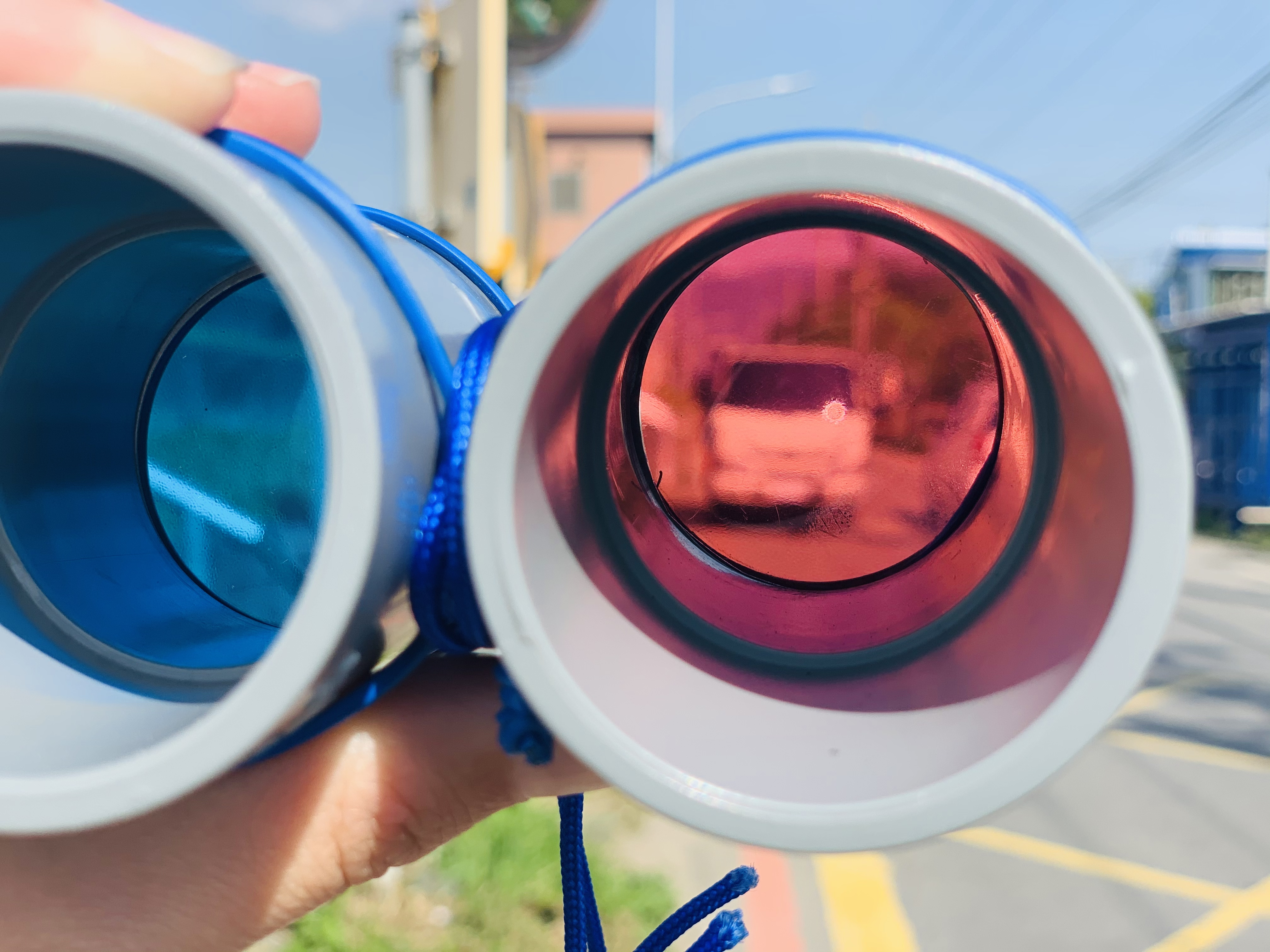
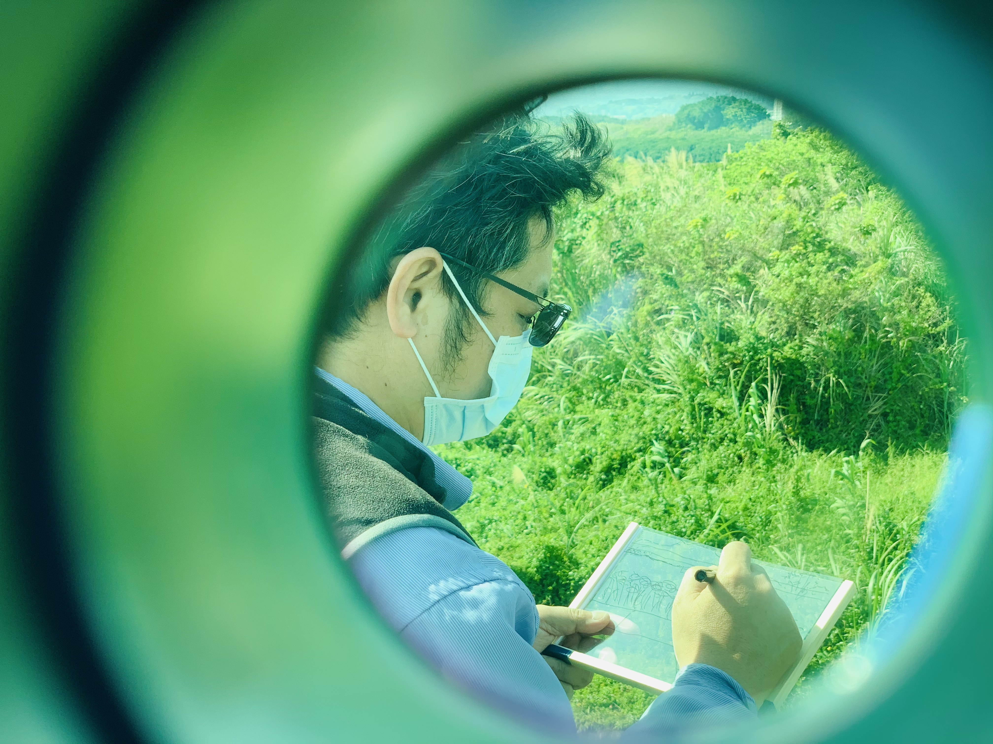

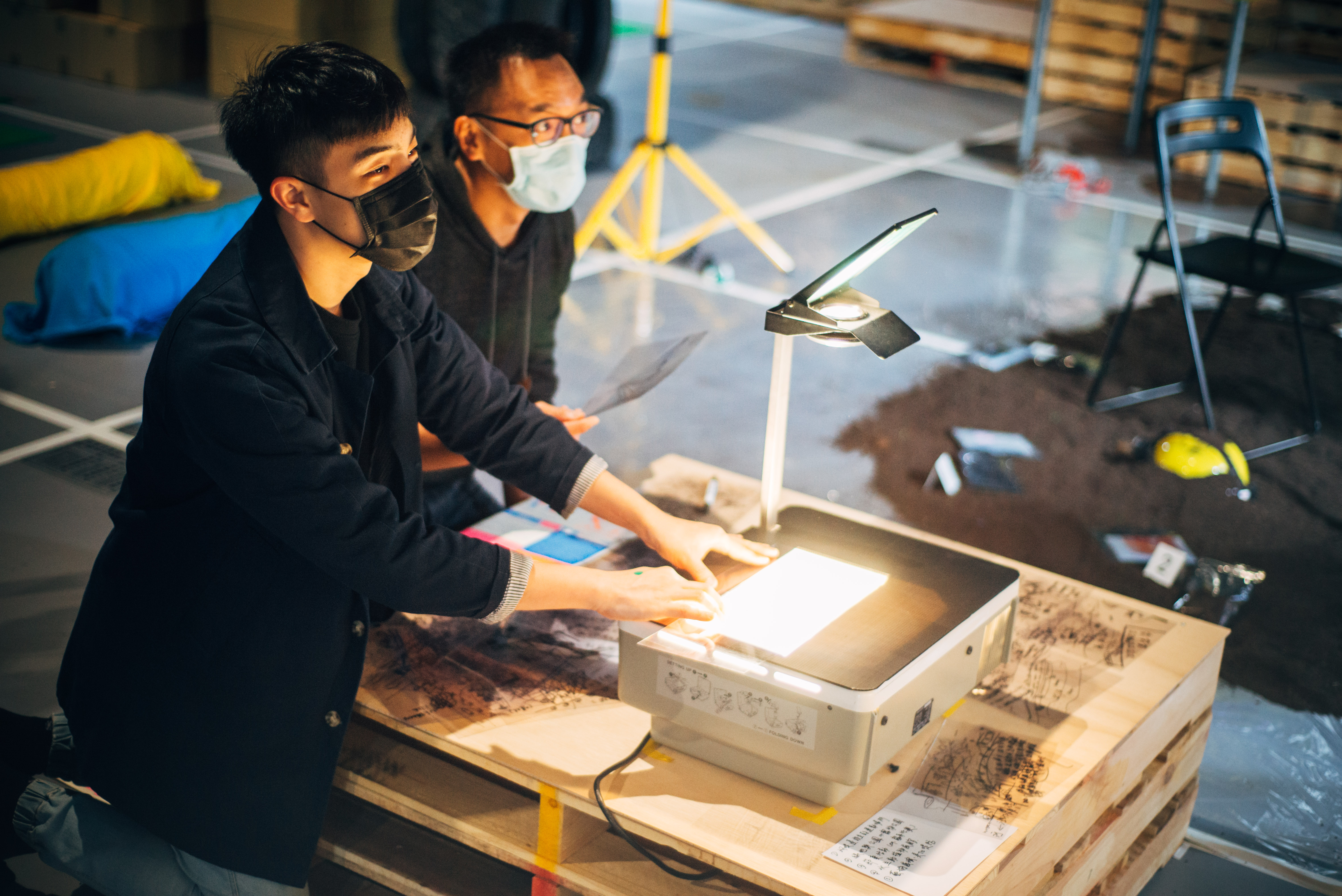
To find the answers, tools have been designed to support each individual’s observations in order to document them afterwards for analysis. The first tool, a binocular with 4-color glasses, each with its own focus. The red glasses are
for comfort and help the eyes to adjust with the contrast, increasing the depth of the field as they block the blue and green light for 100%. The yellow glasses provide a greater clarity, increasing the contrast and giving the participants a sharper view. As for the green glasses, they filter yellow and blue light off, reducing the glares and brightening the shadows. Finally, the blue color glasses improve the contours around objects and increase the color perception.
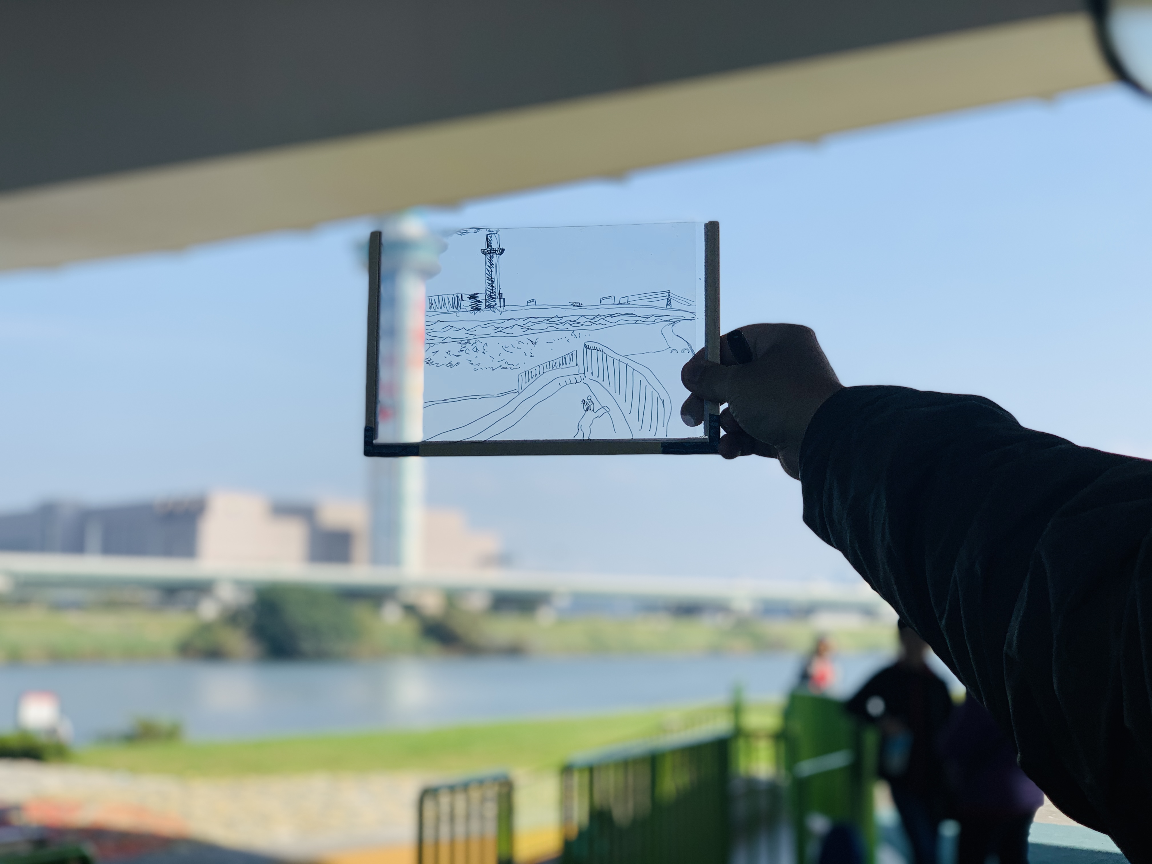
The second tool is the drawing panel to portray individuals’ observations- a transparent frame where the participants literally trace their observation in the air. Without the necessity to think about the quality of the sketching, the participants are encouraged to concentrate on what they see and simply follow the contours.
observations subjects
- sound
- objects
- material
- accessibility - activities
- users
for comfort and help the eyes to adjust with the contrast, increasing the depth of the field as they block the blue and green light for 100%. The yellow glasses provide a greater clarity, increasing the contrast and giving the participants a sharper view. As for the green glasses, they filter yellow and blue light off, reducing the glares and brightening the shadows. Finally, the blue color glasses improve the contours around objects and increase the color perception.
The second tool is the drawing panel to portray individuals’ observations- a transparent frame where the participants literally trace their observation in the air. Without the necessity to think about the quality of the sketching, the participants are encouraged to concentrate on what they see and simply follow the contours.
observations subjects
- sound
- objects
- material
- accessibility - activities
- users

Translation
The second part of the workshop aims
to translate the personal observations
into proposals which focus on the spatial and social aspects in order to create new additional models for the dike around Shezi- island. According to the flowing steps, the participants create proposals in groups.
1. Analysing and collecting
test your observations accordingto the following topics
1.1)Accessibilities at the location
1.2) Application from the profile of the dyke
1.3)The spotted users
1.4)Visual language
2. Learning and translating
2.1) What did you miss at the location?
2.2) What were the qualities?
2.3)and how to maintain them in the future?
2.4) How do you unfold the hidden layers?
3. You as a creator
3.1) Creation of conceptual ideas
3.2) Storytelling
3.3) Design based on an experience or
spatial integration


1. Looking back
What was there first? The dike or the city? Due to the limited space and integration, the conclusion is that the city was there first. Once the dikes were completed the river was directly isolated from the city and its inhabitants; from day to day, the outside dike cannot be perceived and visible from the city side. Therefore, the floodwall clearly divided the public space into the inside dike (the city) and the outside dike (riverside) which didn’t have any relation with each other.
What was there first? The dike or the city? Due to the limited space and integration, the conclusion is that the city was there first. Once the dikes were completed the river was directly isolated from the city and its inhabitants; from day to day, the outside dike cannot be perceived and visible from the city side. Therefore, the floodwall clearly divided the public space into the inside dike (the city) and the outside dike (riverside) which didn’t have any relation with each other.
2. Floodwall VS Eerth dike
In 1971, the Flood Control Plan was drawn up.
A difference in zones based on the degree of protection was established. This has resulted in 2 types of dikes: the floodwall and the earth dike. A cold concrete wall of 9.65m high was placed at the most metropolitan area of Taipei. This was seen as the only solution because the space between the river and the city was drastically minimal. On the other hand, Shezi-island, the political backyard of Taipei, a sandbank that has been shaped by the natural process of the river, was identified back in the time as a flood plain in the downstream section of the Keelung River. This led to a lower investment with a lower earth dike as protection.
3. Temprorary alternatives
Due to the possible announcement of floods, many temporary facilities in the outer dike
area have been set up. Movable self-sufficient objects such as toilets, drinks and food vending machines are examples. These are temporary objects that must be collected when a flood is announced and moved to the inside dike area. In addition to setting up temporary catering establishments, renting a place to keep karaoke and large open areas indicate that the use in the inside dike area is prepared for flooding.
The climate in Taipei requires shadowy shelters in the fight with the sunlight. Due to the limited 32
number of trees that may be allowed in the outside dike area, spaces under the bridges that connect the city with New Taipei City, offer an alternative possibility for temporary use for the public.
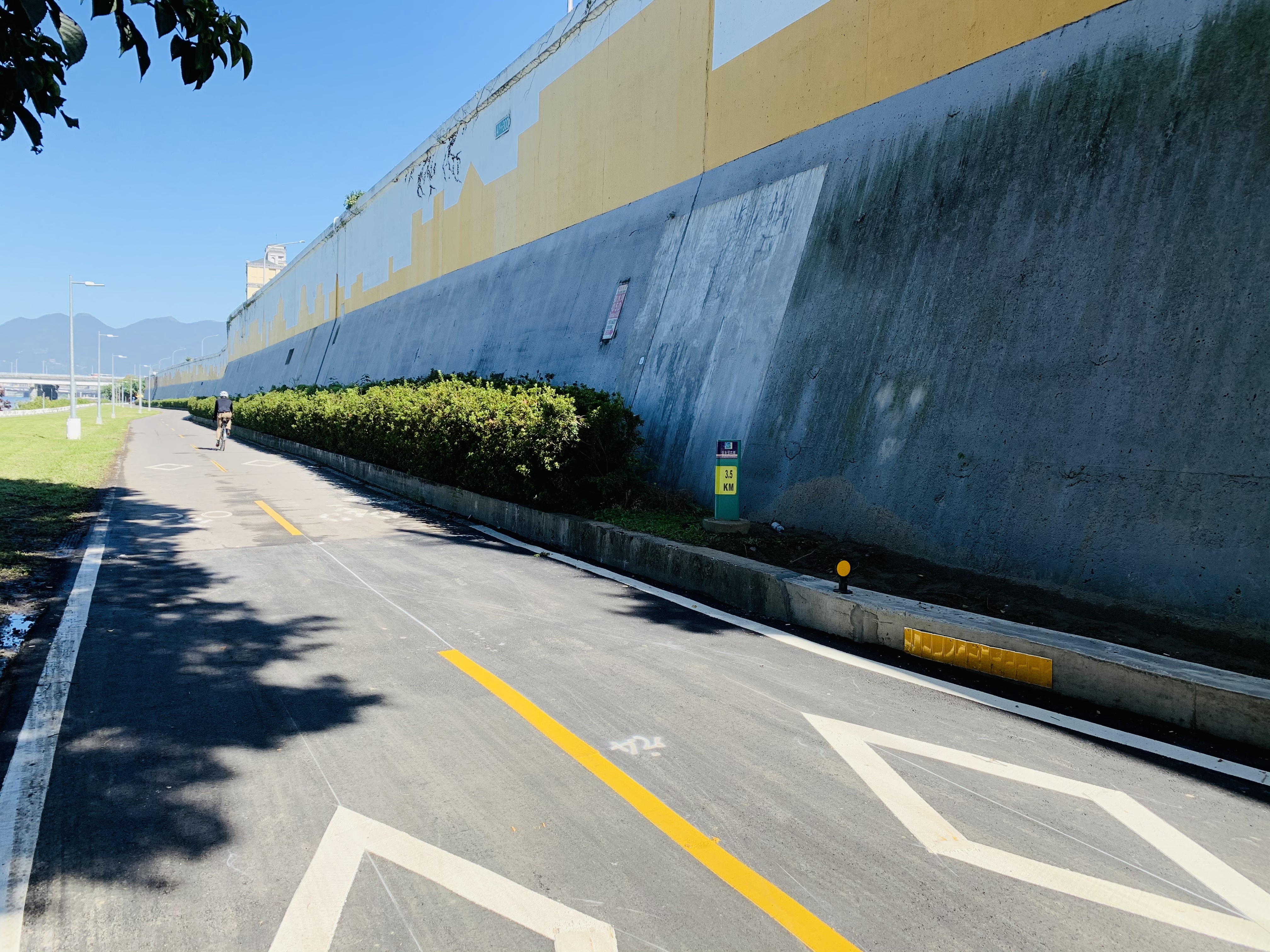
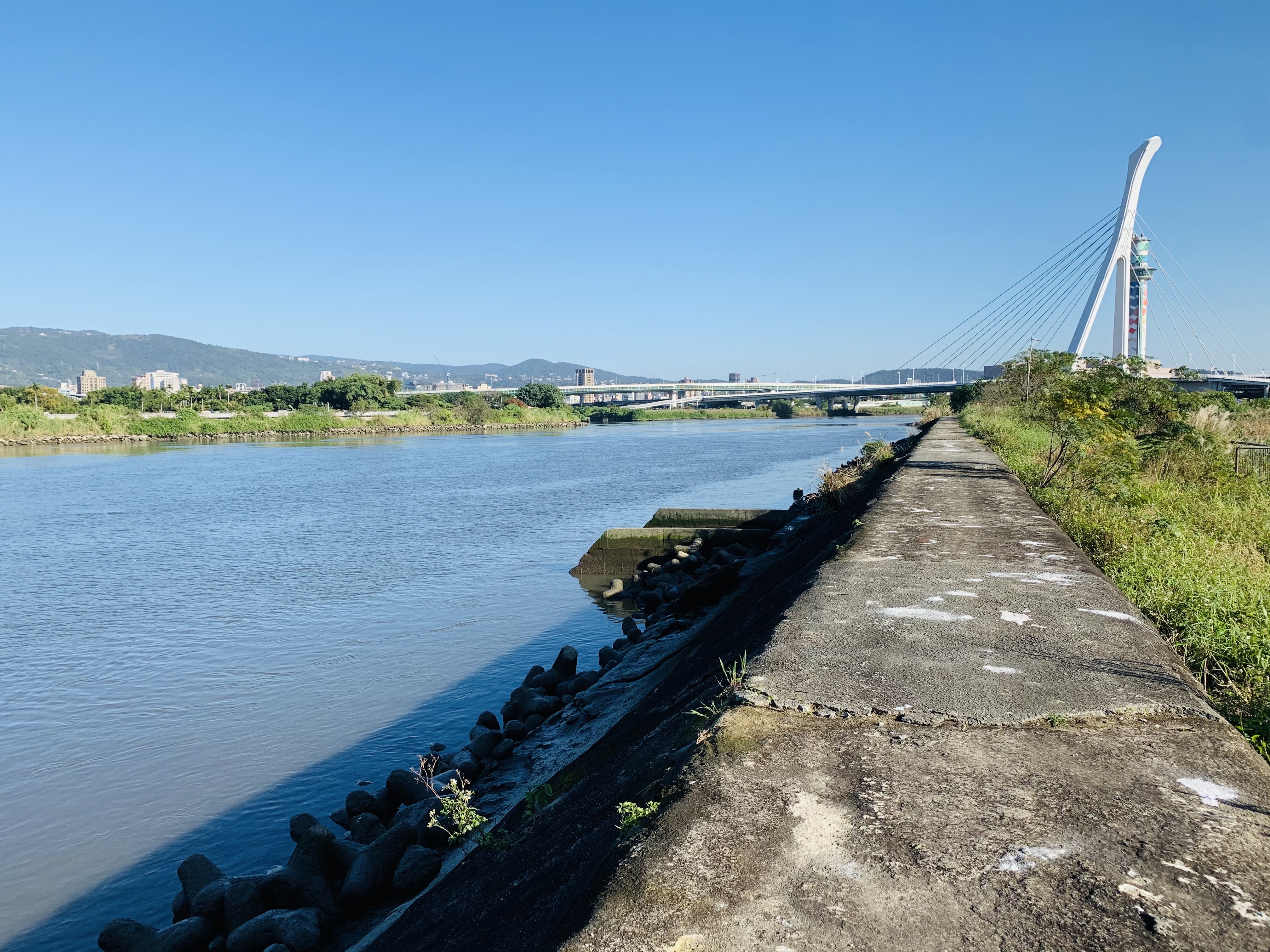
4. Missing Accessibilities
How close can you get to the river? All applications in the public area show examples that you can only experience the river from a distance. Or from a raised quay edge. But in reality, full access to the water is blocked.
In recent years, developments have been made in public space in the area outside the dike, following the regulations of the flood control plan. Such as viewpoints, restplaces and birdwatch houses. However, the accessible public spaces in the area inside the dike have continued to deteriorate; since the main infrastructure or access to the city is still built directly along with the wall and the dike. Therefore this has created a double obstacle for slower traffic from the city (especially for cyclists and pedestrians) to reach the area outside the dike next to the river. As a result, the dike remains as an obstacle in its own right and there is a lack of the missing link for the horizontal, social and physical interactions from the river to her city, and vice versa.
6. The other way around
The main question that has been raised now is how we get more diverse activities around or on the river when the threat from the flood is not there. What are the new possibilities within new developments? Will the result be different if we take the dike as a starting point?
In the new strategy, the first step is to look for the weakest points of the dike. The second step is to reinforce the dyke where needed while the final step is to add social interaction. The difference is that we don’t only look at the outside dike but also at the inside dike. Parallel to the last step,
the connection in the developments of urbanization will be included. In this way, the dike will no longer be an obstacle but a connecting element between the river and the city, as an accessible public space.
7. The interactive dike
The research has brought together the perspective of an outsider combined with the local experience. How does the social relationship influence the use of both the inside and outside dike at the present? And how does the new relationship turn the obstacle into a key for new opportunities?
The toolbox is a strengthening point to map out these new possibilities. The input of the participants is brought together with the expertise of the landscape designer/artist.

Keelung, Taiwain
THE RAIN
HEROES
HEROES


2021 - Keelung - Taiwan
Invited Contributor for Artist Residency
Zhengbin Creative School
Rainy Village, Taiwan
The rain Heroes
The project stimulates the audience’s imagination to create a dialogue between nature and human behavior. With the theme ‘The Rain Village’, we are looking for the interpretation and creation of thoughts on the relationship between the rain and the island culture.
I was paired up with weather expert Mr. Lin from the weather-station in Keelung. Together we created a new learning environment, in which thetechnical knowledge of the flow of rain was be transferred into an art form:
The Rain Heroes!


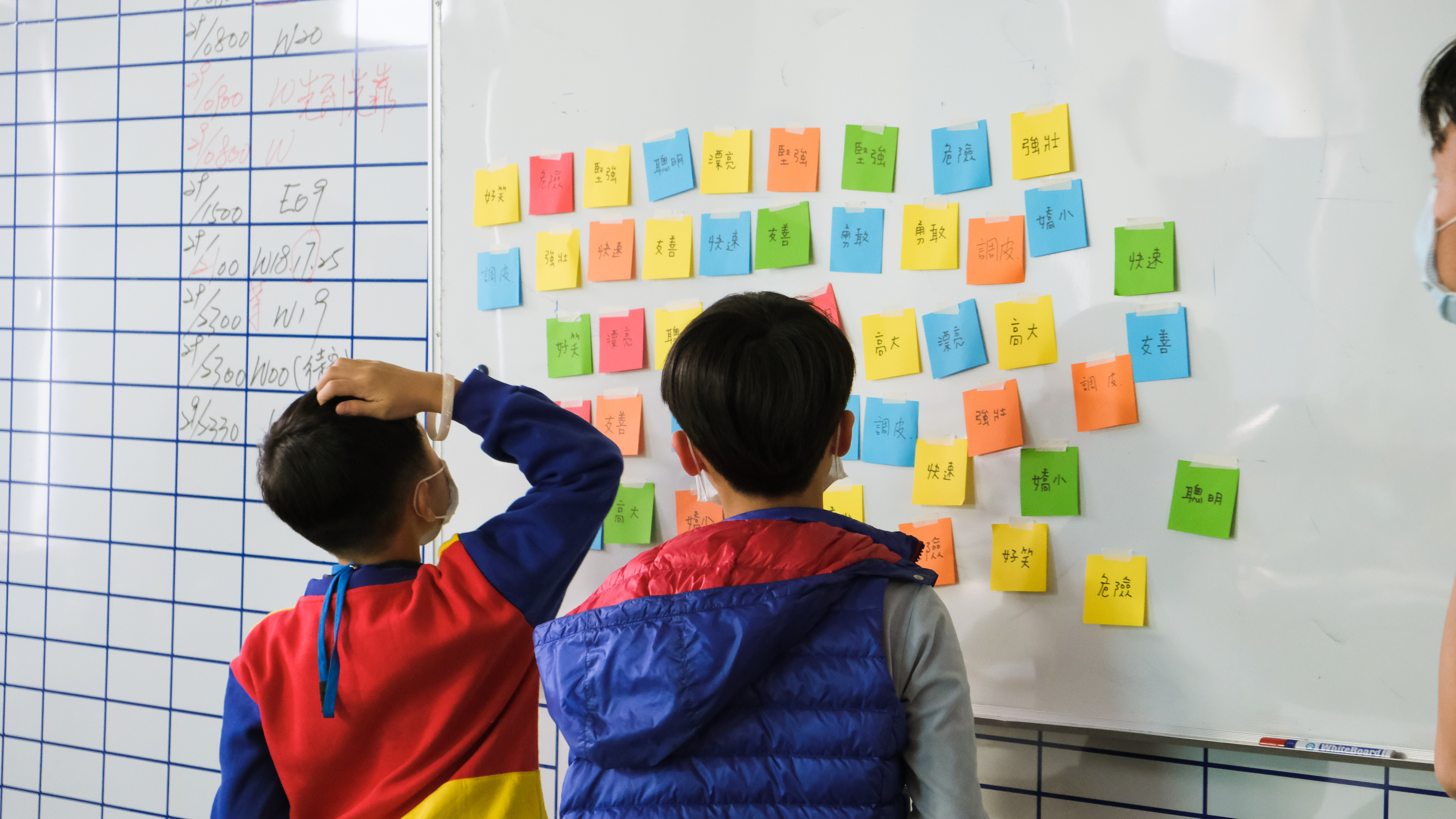
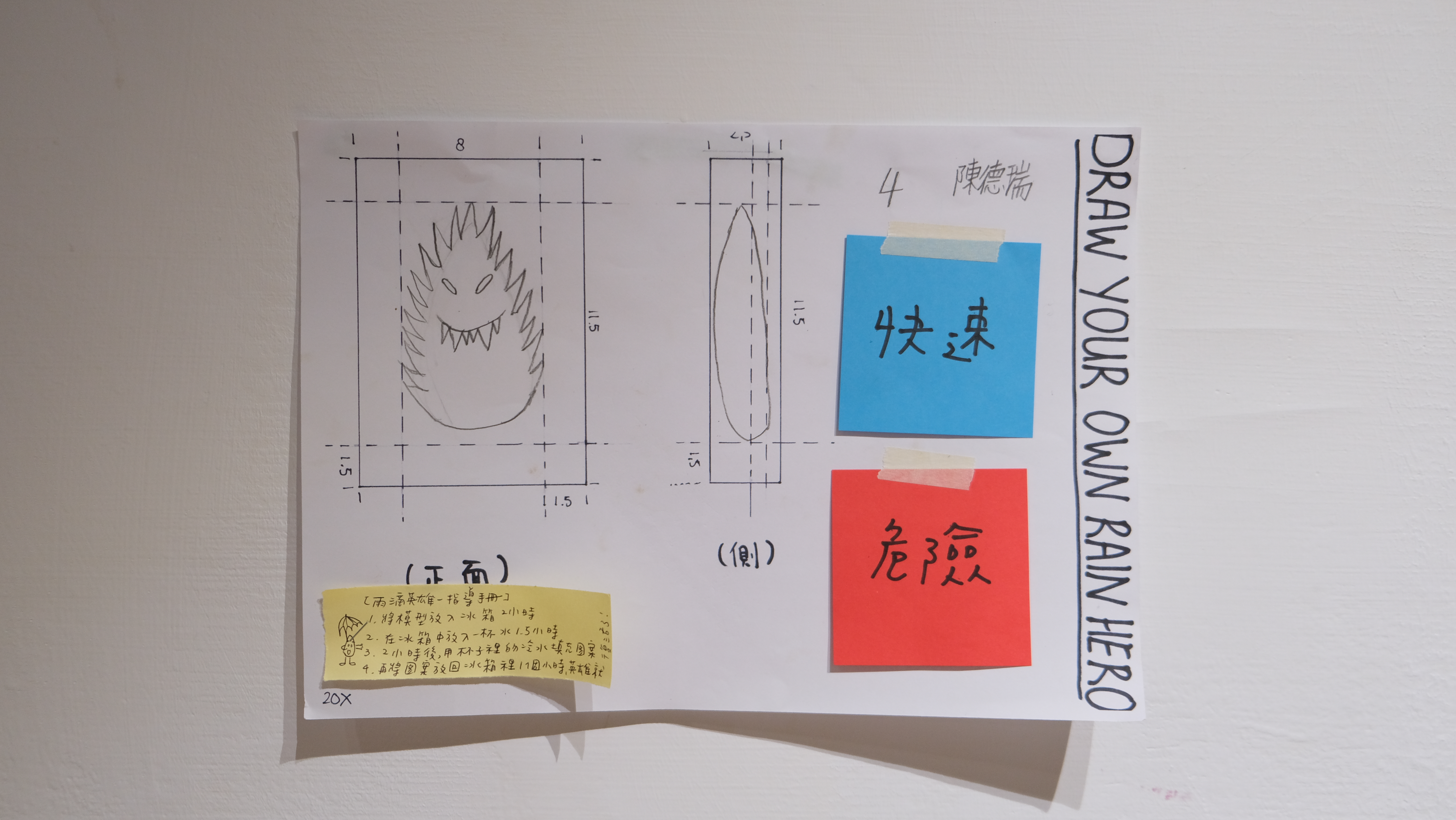
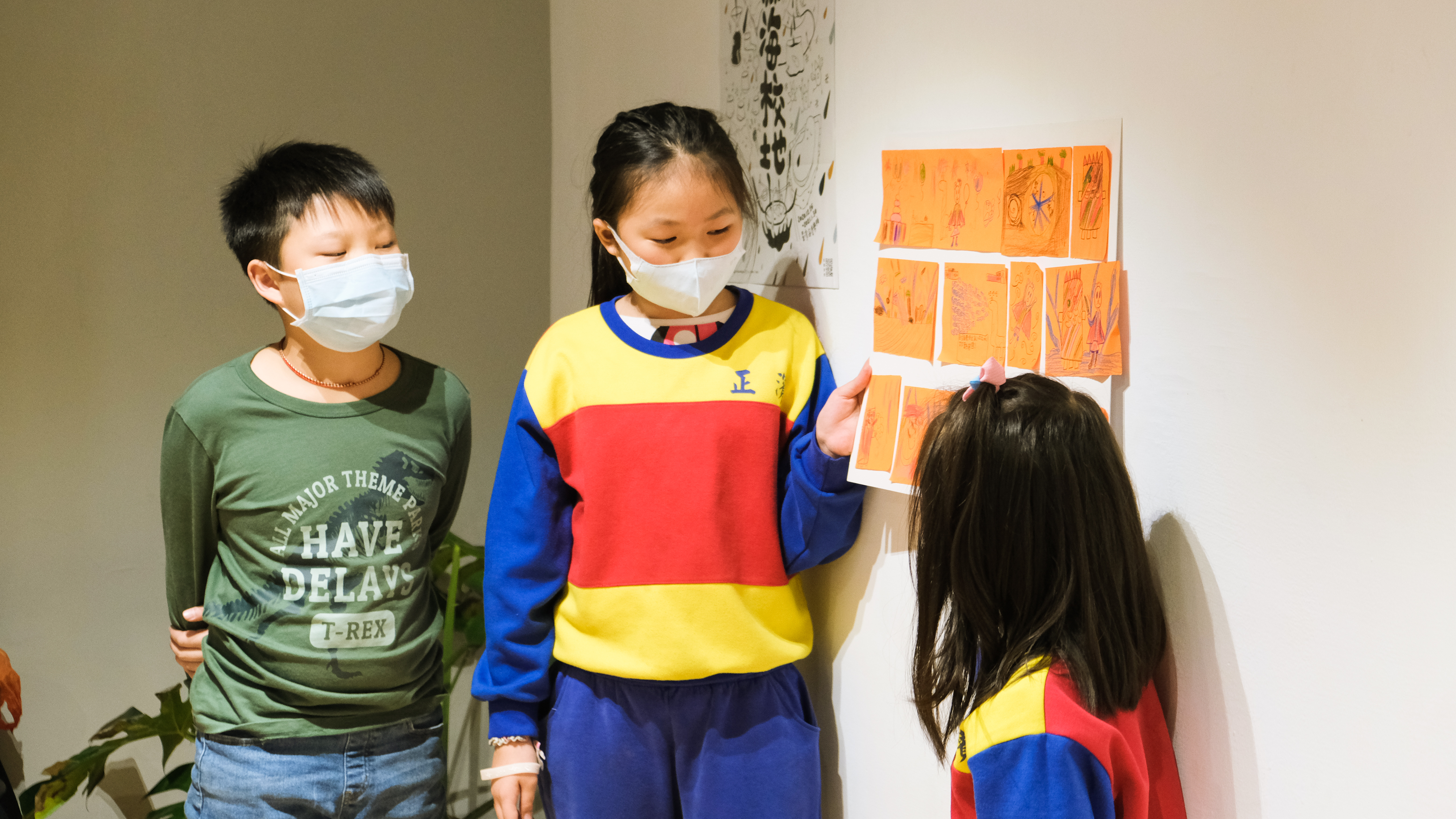
How to extend the
visible time of rain?
In the first step the kids draw
their rain hero in 2D
in the second step they made
with clay a 3D model.
Where in the last step the pattern was created.
The pattern is ready now to collect
the rain and to put in the freezer.
After 2,5 hour the rain hero is born
and isvisible before it returns
back to its original habitat.


jannekederksen 2025 — Rotterdam, The Netherlands